- Giới thiệu
- Nhóm Công tác
- Tin tức
- Thông tin về FTA
- Tài Liệu
- Sự kiện
- Liên hệ
Climate smart map and adaptation plan in response to climate change
On October 19th, the MARD has held the policy dialogue event and the publication of climate smart map and adaptation plan (CS-MAP) with the support of the Southeast Asia Research Program on Climate Change, Agriculture and Food Security (CCAFS).
The event was chaired by MARD Deputy Minister Dr. Le Quoc Doanh, and jointly organized by the Department of Crop Production (DCP) of MARD and CCAFS SEA, both in-person in Hanoi and online via Zoom for national and international delegates. The event attracted the attention and participation of different stakeholders and partners from the national agencies, 43 provinces implementing CS-M, and other related agencies from other countries.

MARD Deputy Minister Dr. Le Quoc Doanh making the opening speech. Photo: Nongnghiep.vn
Making the opening speech at the workshop, Deputy Minister Le Quoc Doanh shared that the COVID-19 pandemic has been causing heavy damage to global health, economy and social security. Supply chains are disrupted, production and food security are severely affected.
In particular, food production resources are increasingly scarce. The negative impacts of progressive climate change have been and are major challenges in ensuring food security for 7.9 billion people in the world.
The Ministry of Agriculture and Rural Development of Vietnam is always keenly aware of the issue regarding responses to climate change, turning disadvantages into advantages. To realize these actions, the agricultural sector has been continuously making progress in transforming plant structure, selecting and breeding new plant varieties, and apply appropriate technical advances to production.
Vietnam, for that reason, welcomes and highly appreciates the publication of the climate smart map and adaptation plan (CS-MAP), jointly developed by the DCP-MARD and CCAFS SEA along with the country’s localities. The document will support localities and farmer households to develop and implement production plans, select and create appropriate crops, limit the damage caused by climate change, and improve land and water usage efficiency.
The CS-MAP is a participatory approach that integrates local knowledge and science-based researches in developing climate-related risks maps and adaptation plans for rice production, suitable to location-specific conditions. It has been effectively implemented in five ecological regions of Vietnam in order to help farmers mitigate climate-related risks, such as flooding, drought and salinity intrusion.
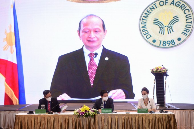
Dr. Leocadio Sebastian, CCAFS SEA Program Leader. Photo: Nongnghiep.vn
As stated in the presentation of the policy document, CS-MAP can be integrated into national and sectoral policies and plans, such as in the National Plan to adapt to climate change, Nationally Determined Contribution (NDC) to climate change mitigation in the agricultural sector, and the national and regional agricultural restructuring plan for the period 2021-2025.
At the local levels, CS-MAP, as a tool for climate change adaptation and disaster prevention, was proposed to be included in the socio-economic plan for the period 2021-2030, action plan to respond to climate change for the period 2021-2030, and agricultural land use planning (including rice land conversion), among others.
CS-MAP holds an important and valuable position in agricultural policy in response to climate change. CS-MAP provides great support for smart agriculture: ensuring food safety, increase income and economic efficiency through the growth of food production; increase the agricultural production systems’ adaptability to climate change; reduce greenhouse gas emissions from agricultural activities.
Aside from the policy discussion, the event also highlighted the official turnover of various CS-MAP knowledge products to local partners. An instructional video and guidebook on CS-MAP, as well as five CS-MAP atlases, were produced to ensure the sustainability of CS-MAP application and build the capacity of local implementers

Five compilations of CS-MAPs for the major agro-ecological regions of Viet Nam were also launched and handed over during the event. Photo: Nongnghiep.vn
Five compilations of CS-MAPs for the major agro-ecological regions of Viet Nam were also launched and handed over during the event. The CS-MAP atlases are for Mekong River Delta, Northern Midlands and Delta, South Central Coast, North Central Coast, and CS-MAP pilot for perennial crops. These publications contain all the maps, both for normal and extreme years, covering 43 provinces of the country.
To further promote the application of CS-MAP, DCP and CCAFS SEA cooperated in publishing a guidebook, which would help technical officers and professional agencies at different administrative levels to implement CS-MAP. CCAFS SEA also produced a video on how to develop and implement the CS-MAP.
Source: Nongnghiep.vn
Tin liên quan
PSAV Attends the 30th Anniversary Celebration of Cargill Vietnam2025/10/23
Plant health management helps increase coffee yield up to 15%2025/10/16
An Giang to host 2025 OCOP forum for sustainable development2025/09/25
Viet Nam and France foster cooperation on blue economy and sustainable environment2025/09/29
Agriculture and Environment exhibition ready for National celebration2025/08/27


 Điều lệ hoạt động
